First tropical storm warning of hurricane season issued as coastal Texas braces for possible flooding

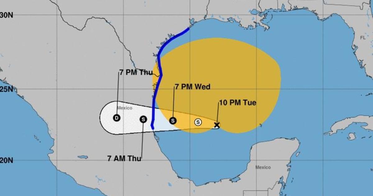
The first tropical storm warning of this year’s hurricane season was issued early Tuesday, as coastal communities in southern Texas prepare for an oncoming bout of heavy rain, flooding and, possibly, tornadoes. The storm was developing over the southern Gulf of Mexico and expected to reach land as a potential tropical cyclone, according to the National Hurricane Center.
If the storm becomes strong enough it will become the first named storm of the season: Tropical Storm Alberto.
As of Tuesday night, the system was centered about 365 miles southeast of Brownsville, Texas, according to the hurricane center, and was forecast to be become a tropical storm by Wednesday and reach Mexico’s Gulf Coast by Wednesday night. There was an 80% chance the system would become a tropical storm within the next two days.
#One Advisory 5A: Heavy Rainfall, Coastal Flooding and Gusty Winds Expected Along The Coasts of Texas and Northeastern Mexico Through Thursday. https://t.co/tW4KeGe9uJ
— National Hurricane Center (@NHC_Atlantic) June 18, 2024
Forecasts Tuesday night indicated that the system was already packing maximum sustained winds near 40 miles per hour, which would likely increase in strength over the next 36 hours. Downpours and coastal flooding were expected over the next day or two.
“The disturbance is very large with rainfall, coastal flooding, and wind impacts likely to occur far from the center along the coasts of Texas and northeastern Mexico,” the hurricane center said in a Tuesday advisory. Meteorologists noted that tropical storm force winds extended up to 415 miles outward from the core of the disturbance, which remained “large but disorganized” over the western Gulf at 1 p.m.
In Texas, the hurricane center said moderate coastal flooding could begin along the coast as soon as Tuesday and continue through the middle of the week. The situation was forecast to worsen on Wednesday for people in the tropical storm warning area, where flash flooding and flooding in urban areas could accompany overflowing rivers. Mudslides could also happen across northeastern Mexico.
The National Hurricane Center upgraded what had been the current season’s first tropical storm watch to a tropical storm warning at 4 a.m. CT on Tuesday. Three hours later, the government of Mexico issued a tropical storm warning for the parts of the country’s northeastern coast, south of the mouth of the Rio Grande to Puerto de Altamira, replacing the tropical storm watch previously effected there. The difference accounts for timing — forecasters will generally issue a “watch” when tropical storm conditions are possible in the impacted area within roughly 48 hours, and a “warning” when the conditions become more imminent, about 36 hours out.
This week’s potential storm was moving northwest at 7 mph over the Gulf Tuesday evening. It was expected to turn west overnight and into Wednesday, before reaching northeastern Mexico by Wednesday night, the hurricane center said. Places across northeastern Mexico and southern Texas could see between 5 and 10 inches of rainfall, although forecasters noted that inundation could be more severe in some areas.
“The combination of dangerous storm surge and the tide will cause normally dry areas near the coast to be flooded by rising waters moving inland from the shoreline,” read a Tuesday advisory from the hurricane center issued at 10 p.m. CT.
If peak storm surge tied to the potential storm occurs in tandem with high tide, forecasts suggested that flooding could rise as much as 4 feet above ground along stretches of the Gulf Coast in Texas and Mexico. The deepest water was forecast for areas along the immediate coast near the potential landfall location and north of it, where a storm surge will likely be joined by large and dangerous waves, the hurricane center said. Swells from this are expected to create life-threatening surf conditions and rip currents.
The annual Atlantic hurricane season officially began on June 1 and will run through the end of November, with most storm activity typically happening during the later months of that window, between mid-August and mid-October. The terms hurricane and tropical cyclone can refer to the same kind of storm, with meteorologists using tropical cyclone as a broad classification that includes any weather phenomenon where rotating, low-level cloud systems and thunderstorms develop over tropical or subtropical waters, according to the National Oceanic and Atmospheric Administration.
A tropical cyclone is categorized more specifically as a tropical storm once its maximum wind speeds exceed 39 mph. When sustained winds reach 74 mph or higher, it becomes a hurricane.
Emily Mae Czachor