It’s not just rising sea levels – the land major cities are built on is actually sinking, NASA images show
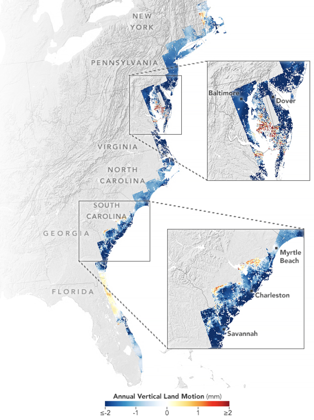
Rising sea levels are threatening the East Coast of the U.S., but that’s not the only thing to worry about, according to NASA. Images shared by the space agency on Tuesday show the coast is actually sinking — including the land that holds major cities such as New York and Baltimore.
A NASA-funded team of scientists at Virginia Tech’s Earth Observation and Innovation Lab found the geographical problem is “happening rapidly enough to threaten infrastructure, farmland, and wetlands that tens of millions of people along the coast rely upon,” NASA said.
Scientists looked at satellite data and GPS sensors to monitor the motion of the coast and found that infrastructure in major cities like New York, Baltimore and Norfolk, Virginia, is built on land that sank between the years of 2007 and 2020. The land subsided, or sank, by an average of 1 to 2 millimeters a year, but some counties in Delaware, Maryland, South Carolina and Georgia saw their land sink twice or three times that fast.
NASA
The land in marshes sinks by more than 3 millimeters a year, the scientists found. Forests have also been displaced due to the intrusion of saltwater and the subsiding land.
another study from the Virginia Tech lab, were published in PNAS Nexus.
The maps shared by NASA were created using data from satellites from the U.S., Japan and Europe. They show the Mid-Atlantic region is sinking more — caused by the Laurentide ice sheet, which started retreating 12,000 years ago, causing the region to sink downward. The sinking continues today and it inversely causes parts of the U.S. and Canada to rise.
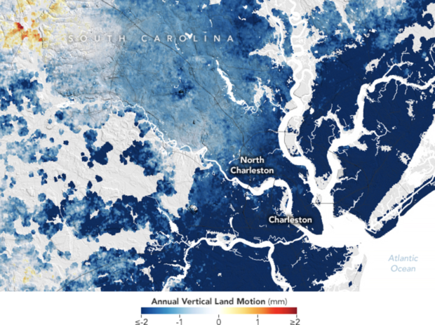
One of the fastest-sinking cities is Charleston, where downtown is just 10 feet above sea level. The city sees subsidence of about 4 millimeters per year. About 800,000 people live in the city, and a portion of the sinking is caused by human activities like groundwater pumping, according to NASA.
To prevent tidal flooding, the city is considering an 8-mile seawall to protect from storm surges.
NASA
Leonard Ohenhen, a geophysicist at Virginia Tech, called the issue of subsidence “pernicious” and “overlooked” compared to rising sea levels. But it’s still a major problem and people living along the coast could see more damage to their homes, saltwater infiltrating farms and fresh water supplies, and other challenges.
Subsidence, however, is a problem that can be slowed locally, said Manoochehr Shirzaei, a co-author on both studies and director of the Virginia Tech lab. Groundwater extraction as well as dams and other other infrastructure can also cause subsidence.
The lab will next use these research techniques on the Gulf Coast, with a goal of mapping all of the world’s coastlines, Shirzaei said.
More
More
Source: cbsnews.com

